Eucentre is a non-profit private law foundation whose mission is to conduct research and provide training and services in earthquake and safety engineering
  Eucentre promotes science, research and innovation for the benefit of the community, offering targeted methodologies and concrete solutions for prevention, safety and resilience. It collaborates with institutions and companies to disseminate competencies for the common good.
 Eucentre conducts earthquake engineering research and risk reduction studies via laboratory testing and numerical analysis to enhance seismic performance and develop innovative solutions
  Eucentre carries out research activities in earthquake engineering and risk reduction through laboratory testing and numerical analysis, aiming to improve the seismic performance of structures and soils and to develop innovative seismic retrofitting techniques.
 The Foundation promotes diverse and high-quality training activities aimed at academic and professional contexts, with constantly updated and innovative programs and initiatives designed to meet the evolving needs of the sector and society
  Eucentre ensures communication aimed at informing institutions, professionals, and citizens about ongoing activities and projects, with the goal of disseminating useful and accessible content and knowledge. It contributes to promoting a shared and informed culture of prevention and resilience.
The Comprehensive Risk Assessment of Basic Services and Transport Infrastructure (CRISIS) project was funded by the European Union under grant agreement: 101004830 – CRISIS – UCPM-2020-PP-AG. Coordinated by IZIIS, the project began in November 2020 and ended in November 2022.
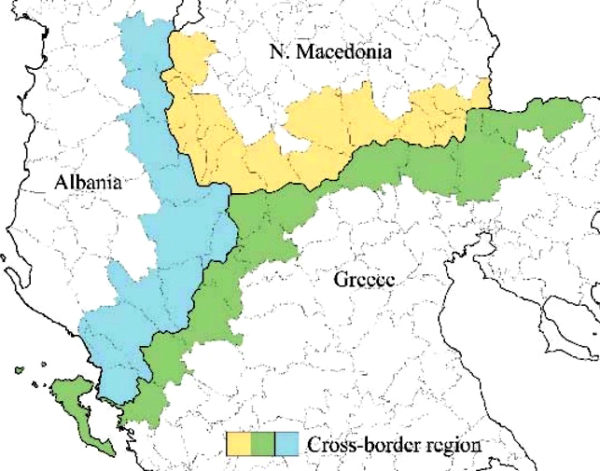
The project aimed to enhance disaster (natural and man-made) and emergency management in the border region of North Macedonia, Albania, and Greece (see image below). The project’s target area, which comprises 18 municipalities in North Macedonia, 11 districts in Albania, and 12 municipalities in Greece, was chosen because it is particularly susceptible to potentially disastrous natural events, especially earthquakes and landslides.
To achieve its objective, the CRISIS project set out to develop an integrated, efficient system for assessing the risk to strategic structures (e.g. hospitals and schools) and road infrastructure in the project area. This system took the form of a WebGIS platform developed by EUCENTRE. The platform’s purpose was to collect, organise, and display data on the structures and infrastructure in the area under consideration, including relevant vulnerability parameters. It could also provide risk information in line with the identified exposure model. It also enabled losses to be forecast and possible malfunctions in critical infrastructure to be identified.
The final results of the project benefited the national civil protection and disaster management authorities in the target area. All the academic institutions belonging to the consortium were involved, and through sharing data and knowledge on the topics covered by CRISIS, they were able to strengthen their mutual cooperation, which will be useful for future collaborations.
The Project Consortium: