 Eucentre è una Fondazione di diritto privato senza scopo di lucro che persegue una missione di ricerca, formazione e erogazione di servizi nel settore dell’ingegneria sismica e, più in generale, dell’ingegneria della sicurezza
  Eucentre promuove Scienza, Ricerca e Innovazione a beneficio della collettività, offrendo metodologie mirate e soluzioni concrete per prevenzione, sicurezza e resilienza. Collabora con istituzioni e imprese, diffondendo competenze orientate al vantaggio comune.
 Eucentre conduce ricerche sull’ingegneria sismica e sulla riduzione del rischio attraverso test di laboratorio e analisi numeriche. L’obiettivo è migliorare il comportamento sismico delle strutture e dei terreni e sviluppare tecniche innovative antisismiche
  Eucentre conduce attività di ricerca su ingegneria sismica e riduzione del rischio, attraverso prove di laboratorio e analisi numeriche, per migliorare il comportamento sismico di strutture e terreni e sviluppare tecniche innovative di consolidamento antisismico.
 La Fondazione promuove attività formative diversificate e di alta qualità, rivolte a contesti accademici e professionali, con programmi e iniziative costantemente aggiornati e innovativi per rispondere alle esigenze in continua evoluzione del settore e della società
  Eucentre assicura una comunicazione per informare istituzioni, professionisti e cittadini sulle attività e i progetti in corso, con l’obiettivo di diffondere contenuti e conoscenze utili e accessibili a tutti. Contribuisce a promuovere una cultura della prevenzione e della resilienza, condivisa e consapevole.
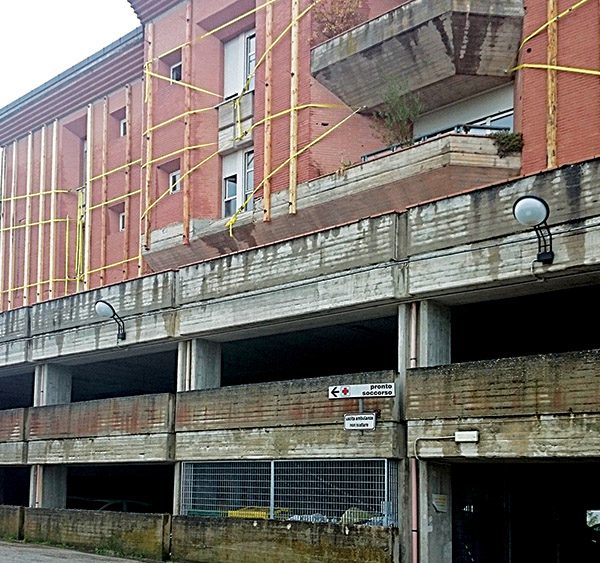
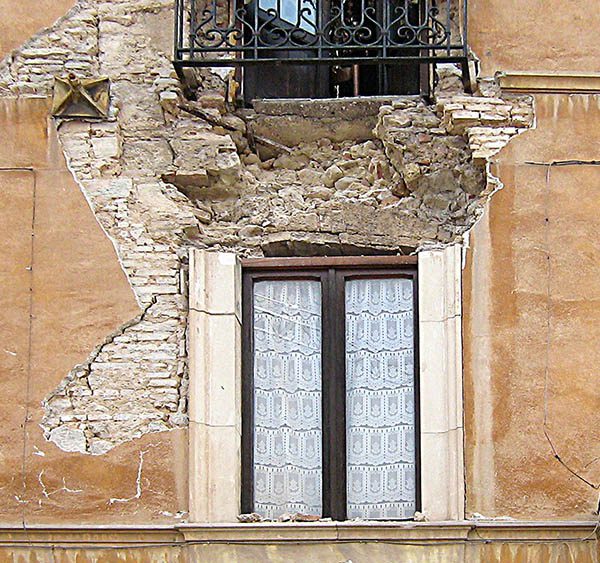
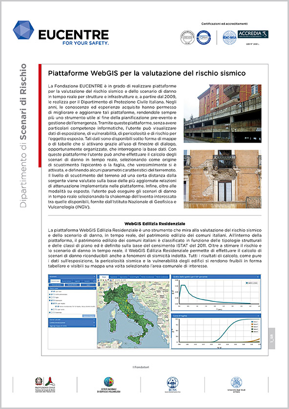
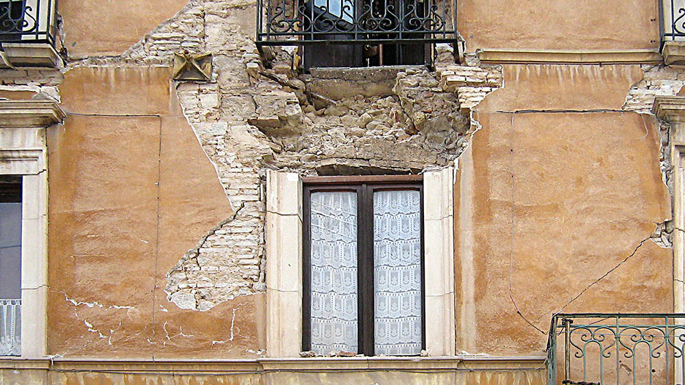
Dipartimento di Scenari di Rischio
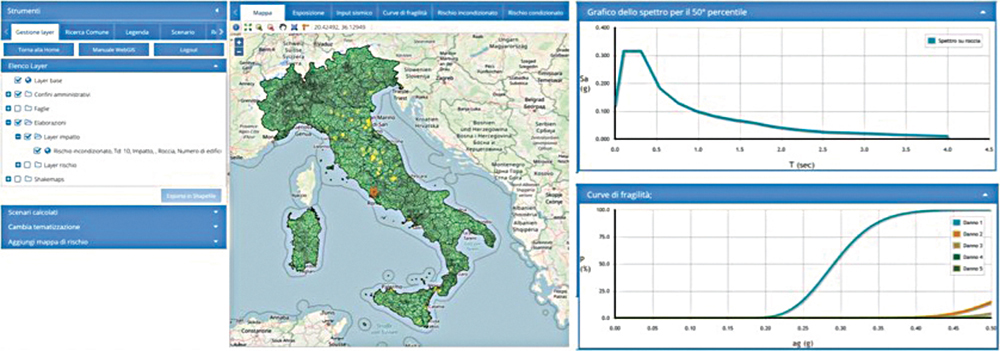
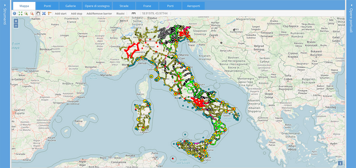
Piattaforme WebGIS per la valutazione del rischio sismico
La Fondazione EUCENTRE è in grado di realizzare piattaforme per la valutazione del rischio sismico e dello scenario di danno in tempo reale per strutture e infrastrutture e, a partire dal 2009, le realizza per il Dipartimento di Protezione Civile Italiana. Negli anni, le conoscenze ed esperienze acquisite hanno permesso di migliorare e aggiornare tali piattaforme, rendendole sempre più uno strumento utile al fine della pianificazione pre-evento e gestione dell’emergenza. Tramite queste piattaforme, senza avere particolari competenze informatiche, l’utente può visualizzare dati di esposizione, di vulnerabilità, di pericolosità e di rischio per l’oggetto esposto. Tali dati sono disponibili sotto forma di mappe o di tabelle che si attivano grazie all’uso di finestre di dialogo, opportunamente organizzate, che interrogano la base dati. Con queste piattaforme l’utente può anche effettuare il calcolo degli scenari di danno in tempo reale, selezionando come origine di scuotimento l’epicentro o la faglia, che verosimilmente si è attivata, e definendo alcuni parametri caratteristici del terremoto. Il livello di scuotimento del terreno ad una certa distanza dalla sorgente viene valutato sulla base delle più aggiornate relazioni di attenuazione implementate nelle piattaforme. Infine, oltre alle modalità su esposte, l’utente può eseguire gli scenari di danno in tempo reale selezionando la shakemap dell’evento interessato tra quelle disponibili, fornite dall’Istituto Nazionale di Geofisica e Vulcanologia (INGV).
WebGIS Edilizia Residenziale
La piattaforma WebGIS Edilizia Residenziale è uno strumento che mira alla valutazione del rischio sismico e dello scenario di danno, in tempo reale, del patrimonio edilizio dei comuni italiani. All’interno della piattaforma, il patrimonio edilizio dei comuni italiani è classificato in funzione delle tipologie strutturali e delle classi di piano ed è definito sulla base del censimento ISTAT del 2011. Oltre a stimare il rischio e lo scenario di danno in tempo reale, il WebGIS Edilizia Residenziale permette di effettuare il calcolo di scenari di danno riconducibili anche a fenomeni di sismicità indotta. Tutti i risultati di calcolo, come pure i dati sull’esposizione, la pericolosità sismica e la vulnerabilità degli edifici si rendono fruibili in forma tabellare e visibili su mappa una volta selezionato l’area comunale di interesse.
WebGIS Scuole
La piattaforma WebGIS Scuole consente la valutazione del rischio sismico e dello scenario di danno in tempo reale delle scuole italiane. All’interno della piattaforma sono presenti 3 database: il primo, e più ampio, è il database dell’Anagrafe dell’edilizia scolastica che raccoglie le schede compilate in tutte le regioni d’Italia. Il secondo è il database delle schede di II livello GNDT, compilate solo in alcune regioni del paese ma con livello di dettaglio maggiore rispetto alle schede dell’Anagrafe per quanto riguarda l’identificazione della capacità strutturale dell’edificio. Infine, ci sono le schede di sintesi della verifica sismica di “livello 1” o di “livello 2” per gli edifici strategici ai fini della protezione civile o rilevanti in caso di collasso a seguito di evento sismico, collezionate per circa 4000 edifici scolastici italiani.
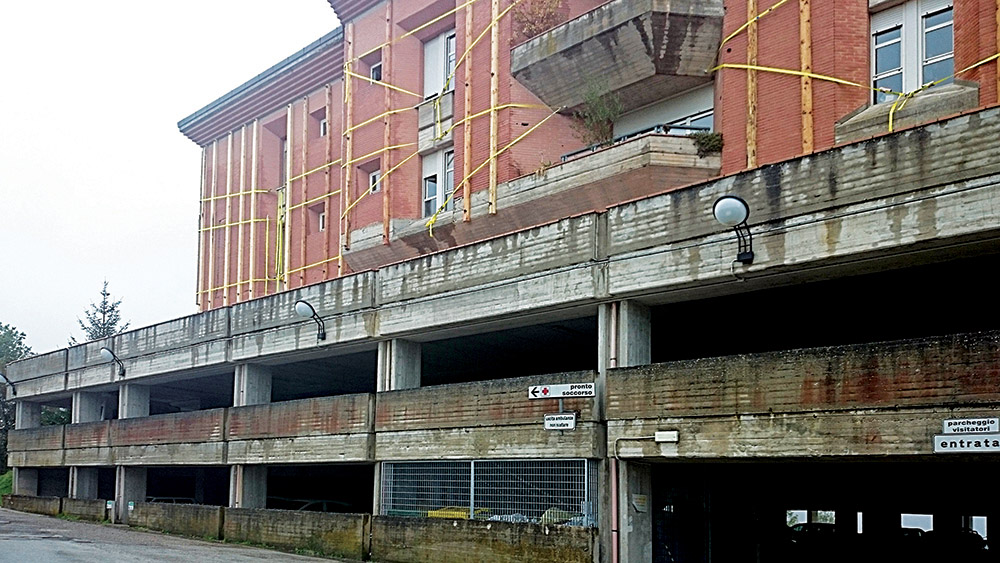
WebGIS Ospedali
La piattaforma WebGIS Ospedali consente di visualizzare i dati relativi agli edifici ospedalieri raccolti con diverse tipologie di schede e il rischio sismico ad essi associato. Le schede presenti nella piattaforma sono le schede di sintesi della verifica sismica di “livello 0”, livello 1” e di “livello 2” per gli edifici strategici ai fini della protezione civile o rilevanti in caso di collasso a seguito di evento sismico. Inoltre, sono presenti schede appositamente sviluppate per gli ospedali della Regione Lombardia collezionate nell’ambito di una convenzione fra la regione stessa ed Eucentre.
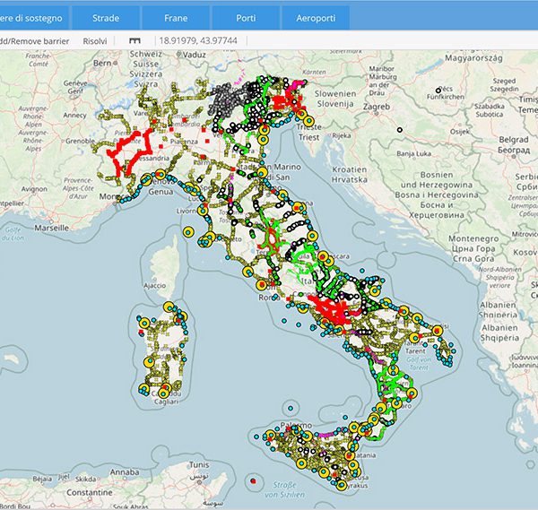
WebGIS Infrastrutture
Il WebGIS Infrastrutture è una piattaforma che permette di calcolare il rischio sismico e gli scenari di danno in tempo reale per le infrastrutture presenti sul territorio italiano. Le infrastrutture prese in considerazione sono quelle del sistema viabilistico, in particolare i ponti, le gallerie e le opere di sostegno, insieme ai sistemi portuali ed agli aeroporti. La piattaforma WebGIS Infrastrutture consente anche di tener conto di eventuali effetti co-sismici, quali ad esempio le frane e, con particolare riferimento alle aree portuali, la suscettibilità a liquefazione. A valle di un calcolo di scenario, la piattaforma permette inoltre di definire strade alternative a quelle più brevi e generalmente usate, quando queste ultime risultano non più percorribili a seguito di una o più infrastrutture danneggiate da un terremoto di una certa intensità. Infine, il WebGIS Infrastrutture mostra l’operatività a seguito di un terremoto di porti ed aeroporti, che rappresentano punti di ingresso (entry points) privilegiati in caso di emergenza. Queste funzionalità sono particolarmente utili agli organi decisionali per individuare in breve tempo i percorsi da far seguire in sicurezza ai soccorsi in caso di emergenza.

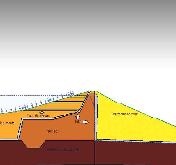
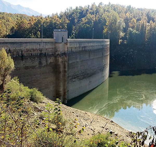
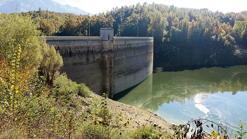
WebGIS Dighe
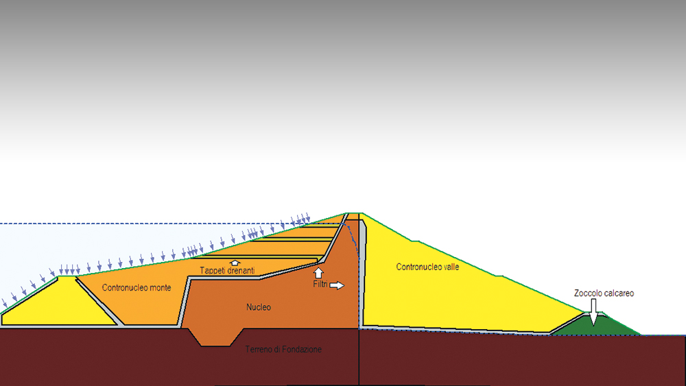
Eucentre ha sviluppato una piattaforma WebGIS delle dighe presenti sul territorio nazionale e del rischio sismico associato a quelle in terra. Nella piattaforma è fruibile un codice di calcolo automatico per valutazioni speditive, “in tempo reale” o “quasi-reale”, della risposta sismica di dighe in terra a seguito di un terremoto reale o di scenario. Nelle fasi immediatamente successive al terremoto, tale valutazione speditiva è utile per capire se il terremoto possa aver indotto danni importanti ad una diga mediante una risposta rapida e di tipo binario (i.e., se esiste o meno un potenziale problema). Analisi più complesse per risultati più precisi richiederebbero tempi di calcolo maggiori ed una notevole quantità di informazioni e dati.

[easy-social-share buttons=”facebook,twitter,google,pinterest,linkedin,whatsapp” counters=0 style=”icon” point_type=”simple”]